- 23 Posts
- 94 Comments

 1·2 months ago
Same problem that Osmand is dependend on their backend for map data download
Wow that’s ridiculous

 1·3 months ago
which version? and what is your opinion about snap?
The map tiles are greyed out and have less contrast then before. Unfortunately there is also no switch setting for normal mode.
Now I use the Mozilla Dark Reader Addon to increase contrast again. Makes the experience of osm.org in dark mode much better.
And here is the chart to follow the progress:
https://taginfo.openstreetmap.org/tags/natural=tree#chronology
We should see a saturation arround 3 trillion trees. (1)
You can easily help achivieving this goal by reworking natural=tree_row and adding single natural=tree into natural=wood areas :) I know, some say this is discouraged, but we really need to map EVERY TREE!
The person to the right?
Sometimes I even think about adding a Google Maps Link to POIs, because of Reviews. The reviews helping a lot to know what to expect from a POI before visiting them.
Thankfully there is no established tag yet.
While StreetComplete is very careful with the quests, my experience with SCEE was much worse. As an example, with current SCEE 58.2 the building color quest is still buggy. The brown, black and white choices are showing wrong colored illustrations.
Therefore SCEE is not a recommendation for me.
I recommend to use the changeset comment to be be used for this kind of plaintext information.
Unfortunately my experience with Organic Maps was, that the changeset comment cannot be changed. And for text put in the comment text field a new map note is created.
I hope that Organic Maps developer team will improve on this and will allow changeset comments.
My suggestion:
- create a single node with leisure=recretion_ground
- add the benches with two more nodes as amenity=bench
- add the wooden structure as building=yes
 6·10 months ago
There is “Oscilloscope” which can show frequencies and their intensity
 61·10 months ago
same would be true for US
Yes that is typically, because there a lot of mappers which are contributing to OpenStreetMap by aerial imagery. Thanks to you that you add stuff from places which you know by yourself. This is very valuable.
Exactly. OpenStreetMap has a big community which is contributing. And every change can be reviewed. Or reverted if its wrong. In the changeset there should also be a source tag like “aerial imagery”, the Editor which was used and also which background imagery was used during edit. For example Bing Maps allows their high resolution imagery to be used for OpenStreetMap.
cool. Would be great if some Linux Distributions would add it to their packages
You can try to send geo URI instead. Most messangers support them.
Example: geo:52.51632,13.37731?z=19
Yes, what we need is the other way arrround! Convert Google Maps Links to OpenStreetMap.org without having to have the Google Maps App.
Nevertheless great that geo-urls are created. This is super helpfull since its supported by OsmAnd, OrganicMaps and much more.
Additionally it would be helpfull if this App registers itself to receive openstreetmap.org and osm.org URLs, so you can just share a link with it instead of copy&paste
PS: the App from F-Droid produces wrong URLs for me like https://openstreetmap/?mlat=0.0&mlon=0.0 ( i provided https://www.openstreetmap.org/#map=5/52.270/11.602)
FitoTrack may be suitable for that.
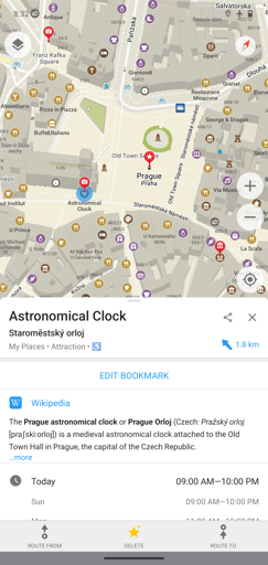
If the Map is not fitting totally you can even correct it on OpenStreetMap.org by yourself
FitoTrack is a nice open source fitness tracker which shows the path on OpenStreetMap background. It logs position and speed data.
You can create a custom workout which shows you the current speed instead of average.
https://f-droid.org/packages/de.tadris.fitness/
What do you actually need it for?


There is no result for “IronFox” on f-droid.org: https://search.f-droid.org/?q=IronFox